


Properties of FAULTS, Key Information to Produce Realistic Generic Earthquake Models and Hazard Simulations (Pilot, starting phase)
Earthquakes, the fault is in the faults…
Academy 3 highlight
Large earthquakes are one of the most damaging and least predictable natural phenomena on Earth. Academy 3 encourages projects that might contribute to a better understanding of this natural hazard. To reach this objective, FAULTS_R_GEMSPILOT fosters new collaborations in UCA among geologists, geophysicists, data science and image processing experts, and mathematicians.
The project
Tectonic faults are large “fracture planes” cutting through the Earth’s crust from the ground surface down to a few (1-10) kilometers depth (general case) or even more. At depth in the crust, faults cannot be observed directly and hence are difficult to analyze. By contrast, as their plane generally intersects the Earth surface, they form clear traces in the ground, generally of 1-1000 kilometers length, which can be observed on the field or from airborne and satellite sensors.
Faults are the Earth features that produce earthquakes; an earthquake is the sudden displacement along a fault of the two rock blocks it separates. Yet, surprisingly, although faults are the source of earthquakes, current earthquake models hardly consider them: the fault source is simplified as a 2D, planar, homogeneous surface with no thickness, embedded in an homogeneous, unfractured medium. This dramatically differs from reality since natural faults are non-planar, 3D zones embedded in intensely fractured rock volumes.
The Faults_R_GemsPilot project proposes that intimate relations exist between faults and earthquakes, which implies that earthquake modeling cannot be successful until it properly integrates fault properties. We have two objectives: firstly, identify and quantify the fault properties which most strongly impact the earthquake behavior; secondly, develop a new generation of earthquake models that integrate these fault properties.
During the 3 years of the Faults_R_GemsPilot project, we have worked on the first objective. Meanwhile, the second task has started in the framework of the larger project Faults_R_Gems since funded by the French National Agency ANR.
To address the first objective, we have 1) acquired large volumes of field, airborne and satellite imaging and topographic data documenting multiple natural fault zones of various scales and earthquake behaviors; 2) adapted deep learning tools to automate the identification and measure of the faults in the image and topographic data; 3) started the analysis of some of the fault properties in the measurements.
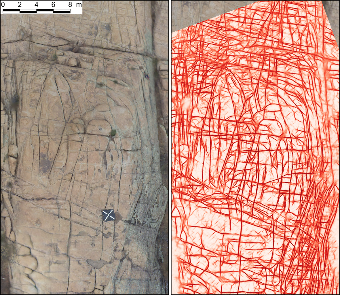
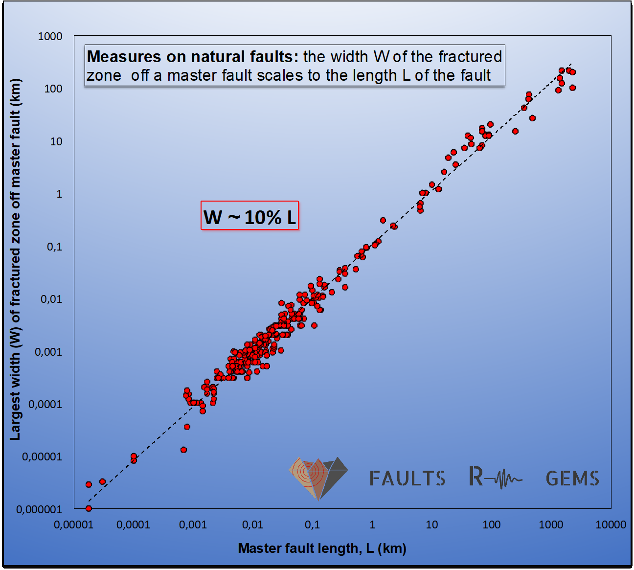
Among preliminary results, the new deep learning tools seem efficient at automatic fault identification in image data (Fig.1); scaling relations exist between important constitutive fault elements (such as fault length and thickness, Fig.2), proving the genetic and generic link between those elements. These scaling relations, key to understand the fault physics, will feed physical and mathematical fault models developed by our partners from LJAD laboratory (project DEFIDEF). Ultimately, these fault models will be integrated into the new generation of earthquake models we are developing.
The +
Deep learning tools are adapted for the first time to automate identification, mapping and measure of faults in remote sensing and airborne data. This is also the first time that actual generic fault properties will be integrated into earthquake models. This new approach, coupling faults and earthquakes intimately, should decrease discrepancies between model outputs and natural earthquake behaviors.
What’s next?
If the results we obtain in the next few years (Faults_R_Gems ANR project) confirm that fault properties are primarily generic, their integration should push forward generic earthquake models that could be run for the vast majority of faults and earthquakes worldwide. These new models might thus open a novel avenue in earthquake modeling and hazard assessment.
Project information
|
Scientific domain
Earth Sciences Theme
Earthquake Hazard |
Key words
Faults
Earthquakes
Remote Sensing
Deep Learning
Scaling Relations
Fault and Earthquake Modeling
|
|
Students inolved
Mattéo Lionel (Phd, Géoazur-Inria-TAS)
Mercier Antoine (M2R, Géoazur)
Serreau Laure (M2r, Géoazur)
Giampietro Tiziano (Phd, Géoazur)
Vincendeau Alexandre (M1, Géoazur)
|
Total budget
about 957 k€ including :
~ 500 k€ from ANR, ~ 100 k€ from Isis program for satellite data acquisition, 3 2 k€ from CNRS interdisciplinary mission, ~ 300 k€ from Ministry of Research, OCA, TAS and UCA funding for 2 PhDs and 1 post-doc Budget Academie 3 : 37 k€
|
| Partner laboratories
INRIA, UCA
LJAD, UCA
Thales Alenia Space (TAS)
CNES
Geosciences Montpellier
International collaboration
Arizona State University (Chelsea SCOTT,
Ramon ARROWSMITH, Tyler SCOTT) UNAVCO, USA (Christopher CROSBY)
Université de Pise (Giancarlo MOLLI)
|
Project members Ampuero Jean-Paul, Géoazur, UCA
Auroux Didier, LJAD, UCA
Berolo Wanda, Géoazur, UCA
Bochra Mejri, LJAD, UCA
Boese Maren, ETH
Cappa Frédéric, Géoazur, UCA
Delvit Jean-Marc, CNES
Dominguez Stéphane, Géosciences Montpellier
Gaucel Jean-Michel, Thales Alenia Space
Gaudemer Yves, Institut De Physique Du Globe De Paris
Hutchison Allie, Géoazur-Eth
Leclerc Frédérique, Géoazur, UCA
Malavieille Jacques, Géosciences Montpellier
Manighetti Isabelle, Géoazur, UCA
Mathieu Sandrine, Thales Alenia Space
Pantz Olivier, Ljad, UCA
Perrin Clément, Institut De Physique Du Globe De Paris
Tarabalka Yuliya, Inria Sophia (UCA) And Luxcarta
Zerubia Josiane, Inria Sophia, UCA
|

Project valorization
Publications:
- Mattéo L., Tarabalka Y., and Manighetti I. (2018). Digital surface model generation from multiple optical high-resolution satellite images. In Image and Signal Processing for Remote Sensing XXIV (Vol. 10789, p. 107890W). International Society for Optics and Photonics.
- Hutchison, A. A., Böse, M., & Manighetti, I. Improving early estimates of large earthquake's final fault lengths and magnitudes leveraging source fault structural maturity information. Geophysical Research Letters, e2020GL087539.
- Jafrasteh, B., Manighetti, I., & Zerubia, J. (2020). Generative adversarial networks as a novel approach for tectonic fault and fracture extraction in high resolution satellite and airborne optical images. ISPRS-International Archives of the Photogrammetry, Remote Sensing and Spatial Information Sciences, 43, 1219-1227.
- Lionel Mattéo, Isabelle Manighetti, Yuliya Tarabalka, Jean-Michel Gaucel, Martijn Van Den Ende, Antoine Mercier, Onur Tasar, Nicolas Girard, Frédérique Leclerc, Tiziano Giampetro, Stéphane Dominguez, and Jacques Malavieille, Automatic fault mapping in remote optical images and topographic data with deep learning, in press at Journal of Geophysical Research - Solid Earth, March 2021.
International conferences:
- Lionel Mattéo, Isabelle Manighetti, Onur Tasar, Frédérique Leclerc, Nicolas Girard, Yuliya Tarabalka, Tiziano Giampietro, Chelsea Scott, Stéphane Dominguez, Martijn van den Ende, Ramon Arrowsmith, Alexandre Vincendeau, Tyler Scott, and Jacques Malavieille, Automatic mapping of fractures and faults in optical images and Digital Surface Models with deep learning, AGU Fall meeting, Dec 2019, San Francisco
- Allie Hutchison, Maren Böse, Frédérik Massin, Isabelle Manighetti, Incorporating fault maturity-related earthquake slip characteristics into final rupture length determination for Earthquake Early Warning, AGU Fall meeting, Dec 2019, San Francisco
- Chelsea Scott, Tiziano Giampietro, Lionel Mattéo, Cassandra Brigham, Frédérique Leclerc, Ramon Arrowsmith, Isabelle Manighetti, Automatic measurement of scarp height along normal faults from high resolution topography in the Volcanic Tablelands, California, Geological Society of America meeting, Sept. 2019
- Giampietro T., Molli G., Malavieille J., Manighetti I., Leclerc F., Antinori A., Structural architecture and damage zones in relay zones of normal fault systems: the case study of Vecchiano (Pisa) and experimental modelling, CRUST meeting, Perugia, Italy, July 2019.
- Manighetti I., Leclerc, F., Serreau, L., Mattéo, L., Scott, C., Scott, T., ... & Crosby, C. J. (2018, December). Tectonic Damage Zones: How Large Across Faults? Insight From Empirical Scaling Relations in Granite Dells Fault Zone, Arizona, USA. In AGU Fall Meeting Abstracts.
- Giampietro, T., Gaudemer, Y., Manighetti, I., Leclerc, F., Billant, J., Dominguez, S., ... & Crosby, C. J. (2020, December). Relative Slip in Damage Zones: Insights from Bishop Tuff Normal Faults. In AGU Fall Meeting 2020. AGU.
- Jafrasteh, B., Manighetti, I., & Zerubia, J. (2020). GAN and U-net abilities to automate tectonic fault mapping in remote sensing optical images. In AGU Fall Meeting 2020. AGU
Diffusion :